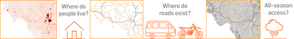
In 2015 the World Bank with assistance from ReCAP introduced a geospatial methodology to measure RAI, using three levels of GIS information:
During the first quarter of 2018, a Status Review was carried out to make recommendations that would support achieving more rapid international progress with the updated measurement of the RAI.
A follow-on project was formulated to consolidate, revise and apply the RAI in pilots. A TRL research team is working with the World Bank as custodian of SDG 9.1.1, other development banks and national authorities to enhance the process for measuring the RAI and promote its use as the key rural access indicator of the SDGs. The second phase has been completed and the third phase started in February 2020.
Details of the original definition and measurement of the RAI can be found in the World Bank report Rural Access Index: A Key Development Indicator (2006).
Information about the UN Inter-agency and Expert Group on Sustainable Development Goals Indicators (IAEG-SDGs) can be found on the IAEG-SDGs web page.
See the World Bank report Measuring Rural Access: Using new technologies (2016) for further details of the pilot measurements.
Project Objectives
The main objective of the Status Review was to assess international progress with the measurement of the RAI/SDG Indicator 9.1.1. and make recommendations to support more rapid and more extensive measurement of the RAI in the future.The objective of the second phase was to develop a harmonised approach to data collection and measurement of the Rural Access Index that was relevant, consistent and sustainable. The third phase aims to consolidate and promote the work carried out in the second phase, and establish a roadmap towards achieving Tier I status on the IAEG-SDG scale. This would require that measurements are carried out by at least 50% of all of the 193 UN countries at regular intervals.
Challenges
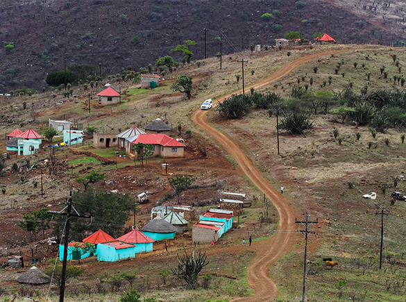
There were some challenges in calculating accurate RAI values for the trial countries (Ghana, Malawi, Myanmar and Nepal). They included:- Finding a common definition of “urban” and “rural”
- Acquiring complete and accurate mapping of the road network
- Defining the all-season status of a road/network
All-season = “a road that is motorable all year round by the prevailing means of rural transport (often a pick-up or a truck which does not have four-wheel-drive), with some predictable interruptions of short duration during inclement weather (e.g., heavy rainfall) allowed.
Accessibility Factors
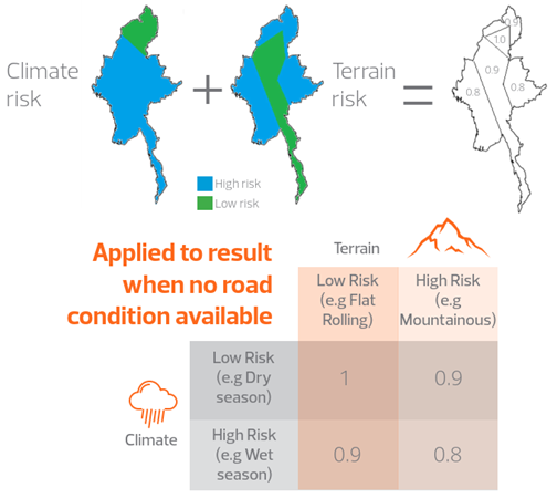
In the 2016 methodology road condition was used to determine the all-season status of roads. The team discovered that condition was not often available for rural road networks, so they devised a way to assess the all-season status without imposing a burden to collect road condition data on countries with limited resources. This involved using Accessibility Factors as a proxy for road condition, as shown below:
RAI Supplemental Guidelines
TRL have developed RAI Supplemental Guidelines, which contain detailed, step-by-step procedures for calculation, documentation and publication of the RAI for a country, are the main deliverable for Phase 2 of the RAI research. They follow the key tenets of the 2016 World Bank methodology captured in the report “Measuring Rural Access: Using New Technologies”, emphasising the involvement of National Statistical Offices (NSOs) and government agencies in the process, and providing transparency and consistency in how the RAI is calculated.
The Supplemental Guidelines, produced by the TRL team in partnership with the World Bank, can be found here.
RAI Measurement Tool
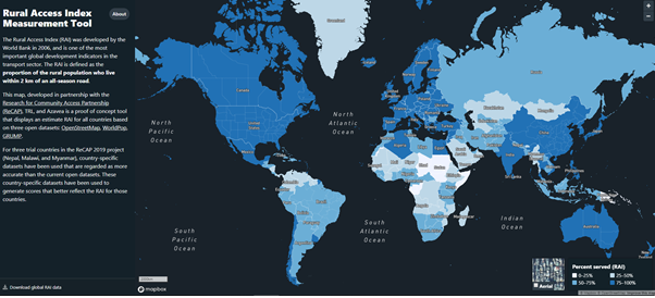
A proof of concept RAI Measurement Tool has been developed by Azavea, which displays the RAI for all countries globally on an interactive geospatial map, based on three open datasets: OpenStreetMap, WorldPop, and GRUMP. It also compares in-country data with the open datasets for three sample countries (Malawi, Nepal and Myanmar).This tool is available here: https://rai.azavea.com
Findings and Recommendations so far
Open data resources are very useful for RAI measurement. WorldPop is an excellent source of population data and OpenStreetMap is improving as a source of road network data. There would be many benefits to reconciling open source data with country data in the long term, for SDG indicators and for general road asset management applications.RAI should be embedded in the national Statistical System (NSS) of a country, in order to ensure that it is measured on a regular basis. International and in-country coordination is also essential.
RAI should be published as absolute numbers, as well as a percentage, as this is a more meaningful way to present the indicator, i.e. ‘53% of the rural population have access to all-season roads’, or ‘7.5 million people do not have access to an all-season road’.
Publication and promotion of the Supplemental Guideline will help to promote measurement of the RAI.
The RAI calculation tool developed by Azavea under ReCAP will be trialed on the UN Global Platform. It has the potential to motivate countries to measure RAI and should make it as easy as possible for countries to carry out RAI measurement independently.
Project Resources and Reports
RAI Status Review, Inception Report, February 2018
RAI Status Review, Interim Progress Statement, March 2018
RAI Status Review, Final Report, May 2018
RAI Status Review presentation, May 2018
Consolidation, Revision and Pilot Application of the RAI, Inception Report, December 2018
Consolidation, Revision and Pilot Application of the RAI, Progress Report 1, May 2019
Consolidation, Revision and Pilot Application of the RAI, Progress Report 2, July 2019
Consolidation, Revision and Pilot Application of the RAI, Workshop Report, October 2019
Rural Access Index (RAI): Supplemental Guidelines, December 2019
ReCAP Rural Access Index Webinar - Part 1: Introduction
ReCAP Rural Access IndexI Webinar - Part 2: RAI in the Sustainable Development Goals
ReCAP Rural Access Index Webinar - Part 3: RAI and Rural Development with Q&A
ReCAP Rural Access Index Webinar - Part 4: RAI Data Sources with Q&A
ReCAP Rural Access Index Webinar - Part 5: RAI Case Study Malawi with Q&A
ReCAP Rural Access Index Webinar - Part 6: RAI Accessibility Factors
ReCAP Rural Access Index Webinar - Part 7: RAI Future Direction, Uganda Demo
ReCAP Rural Access Index Webinar - Part 7: RAI Future Direction, Bangladesh Demo with Q&A